
Description
RPS City Residential Plots Layout Map – Faridabad
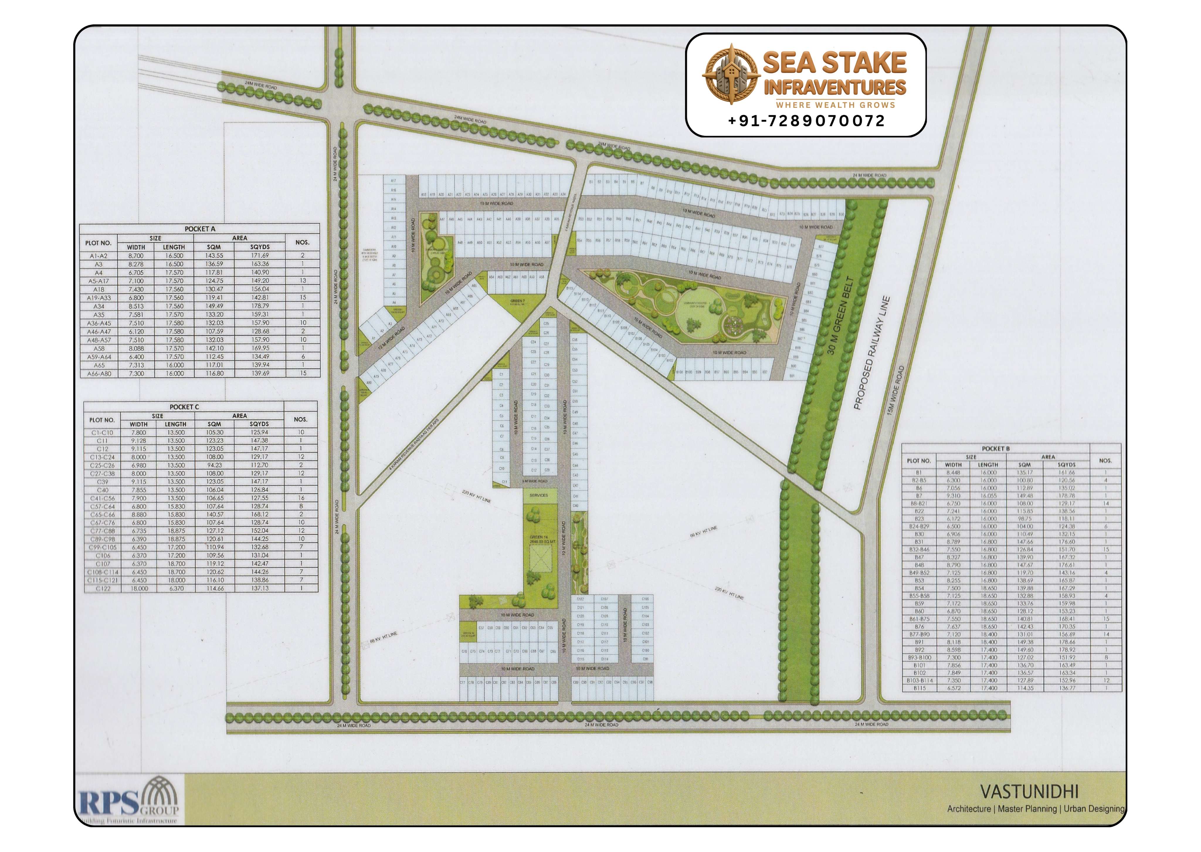
The RPS City Residential Plots Layout Map showcases a thoughtfully planned residential plotted development by RPS Group in Faridabad. The township has been designed with a focus on modern infrastructure, open green spaces, wide roads, and efficient land utilisation, offering an ideal environment for independent home construction and long-term investment.
The master plan is divided into Pocket A, Pocket B, and Pocket C, with residential plots available in multiple sizes to meet the requirements of different buyers. Each pocket is connected through a well-planned internal road network that ensures smooth accessibility throughout the development.
One of the key highlights of the township is its beautifully planned central landscaped gardens, recreational parks, and green open spaces. The development also features wide tree-lined roads, dedicated green belts, and landscaped avenues that create a pleasant living environment.
The layout highlights a 30-metre-wide Green Belt along one side of the township and indicates the Proposed Railway Line, providing a clear understanding of future infrastructure around the project. The master plan has been designed to maximise accessibility while maintaining a healthy balance between residential development and open spaces.
Dedicated service areas, landscaped parks, internal greens, and recreational zones further enhance the quality of life for future residents. The organised planning also ensures excellent movement within the township through wide internal roads connecting every residential pocket.
Key Features of the Layout
- Residential plots in multiple sizes
- Pocket A
- Pocket B
- Pocket C
- Landscaped central gardens
- Theme parks and green spaces
- Wide internal roads
- Tree-lined avenues
- 30-metre Green Belt
- Proposed Railway Line
- Organised township planning
- Premium plotted development
- Excellent future growth potential
The township enjoys excellent connectivity to major roads and important destinations across Faridabad and Delhi NCR. Its strategic location makes it suitable for both end-users looking to build their dream home and investors seeking long-term appreciation.
The RPS City Residential Plots Layout Map serves as an important planning document for homebuyers, investors, architects, builders, and real estate professionals. It clearly presents plot distribution, road hierarchy, landscaped areas, green belts, recreational spaces, and overall township planning before making an informed investment decision.
Sea Stake Infraventures provides verified layout maps, investment consultancy, property guidance, and site visit assistance for RPS City and other premium plotted developments across Faridabad.
Project Highlights
- Verified RPS City Layout Map
- Residential plots
- Pocket A, B & C
- Landscaped central parks
- Green Belt
- Proposed Railway Line
- Wide internal roads
- Premium plotted township
- Excellent connectivity
- Strong investment opportunity
Location Advantages
- Prime location in Faridabad
- Easy connectivity to major sector roads
- Close to established residential sectors
- Well connected to Delhi NCR road network
- Planned township infrastructure
- Near schools, hospitals, and commercial hubs
- Excellent road accessibility
- Green surroundings
- Future infrastructure growth
- High appreciation potential
Why Invest in RPS City Residential Plots?
RPS City offers a well-planned plotted township with organised infrastructure, landscaped parks, green belts, and excellent connectivity. The availability of multiple plot sizes and future infrastructure development makes it an attractive destination for both homebuyers and investors.
Sea Stake Infraventures
Sea Stake Infraventures is a trusted real estate advisory company specialising in verified layout maps, plotted developments, township investments, commercial projects, and professional property consultancy across Faridabad and Greater Faridabad. We help buyers make informed real estate decisions through authentic project information, expert guidance, and personalised investment support.
Frequently Asked Questions
Is this the latest RPS City Layout Map?
Yes. This page displays the latest available layout showing residential pockets, landscaped parks, green belts, and the township road network.
What does the layout include?
The layout includes Pocket A, Pocket B, Pocket C, landscaped parks, internal roads, green belts, and planned residential plots in multiple sizes.
Is RPS City suitable for investment?
Yes. RPS City is a planned plotted township offering organised infrastructure, quality development, and strong long-term appreciation potential.
Can Sea Stake Infraventures help with plot purchases?
Yes. Sea Stake Infraventures provides verified layout maps, investment consultancy, site visits, and complete property assistance for RPS City and other premium projects.