
Description
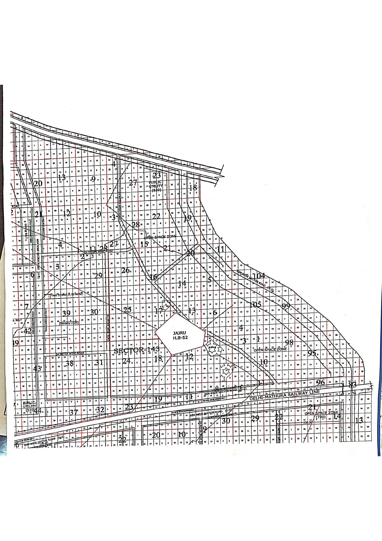
Sector 143 Faridabad – DPP Master Plan and Development Layout
Sector 143 is part of Faridabad’s sector-wise planning framework. The development layout includes numbered land parcels, road corridors, open-space designations and public utility areas. These planning elements help users understand the spatial organisation of the sector and identify details requiring further verification before making property-related decisions.
Land Parcels and Sector Planning
The Sector 143 layout contains numerous numbered parcels arranged in a structured grid across different sections. The central area includes the Jaru H.B.-52 reference, providing an additional geographical identifier for planning research.
Parcel numbers can assist with preliminary navigation and comparison of locations within the layout. Exact plot identification, boundaries, dimensions, ownership and permitted land use should be verified through official records.
Road Network and Transport Corridors
The planned road network forms an important part of the sector’s layout. Multiple road corridors run through and around the numbered parcels, connecting different portions of the area. The arrangement of these corridors is relevant when examining potential access and the relationship between individual parcels and wider transport infrastructure.
Actual road availability, access points, construction status and connectivity should be confirmed independently.
Open-Space Zones and Public Utility Areas
Open-space zones are designated in different parts of the planning layout. These areas are relevant to understanding the distribution of open spaces within the wider development framework.
Public utility designations are also included, indicating areas identified for utility-related purposes. The exact permitted uses, boundaries and current status of these designations must be checked against the applicable official development plan.
Delhi–Mathura Railway Line
The Delhi–Mathura Railway Line is identified along the southern portion of the mapped sector. This railway corridor is an important regional transport reference when studying the surrounding land-use and infrastructure framework.
The presence of a railway alignment does not by itself confirm direct access, nearby station availability, travel times or the absence of railway-related restrictions for a particular property.
Why Research the Sector 143 Master Plan?
The Sector 143 Faridabad DPP map can support preliminary property research by helping buyers, investors and real estate professionals:
-
Understand the numbered parcel arrangement.
-
Identify designated open-space and public utility areas.
-
Examine the relationship between road corridors and land parcels.
-
Locate planning references for further investigation.
-
Prepare questions for property advisers and relevant authorities.
Important Checks Before Buying Property
A master plan is a planning reference and should not be treated as proof of ownership, approval or construction permission. Before purchasing land or property, verify the latest applicable development plan, approved layout, land-use permissions, ownership records, road access and any relevant restrictions with the appropriate authorities.
Sea Stake Infraventures – Faridabad Master Plan Resources
Sea Stake Infraventures provides real estate information and property advisory support across Faridabad, Greater Faridabad and the wider NCR region. Our master plan resources help property buyers and investors begin their research into sector layouts, land-use planning and development patterns.
For property enquiries and assistance with preliminary map research, contact our team.
Call / WhatsApp: 7289070072
9. Key Features / Map Highlights
-
Sector 143 Faridabad planning layout
-
Jaru H.B.-52 geographical reference
-
Numbered land parcels
-
Open-space zones
-
Public utility designations
-
Road corridors and service-road markings
-
Delhi–Mathura Railway Line
-
DPP New 2031 planning reference
10. Location and Connectivity
Sector 143’s planning layout includes road corridors and a railway alignment reference. These features provide context for understanding the wider transport framework, but precise distances to highways, railway stations, metro stations, schools and commercial centres should be added only after location-specific verification.
11. Why Explore This Master Plan?
-
Research the sector’s parcel arrangement.
-
Understand the road network represented in the plan.
-
Identify open-space and public utility designations.
-
Support preliminary land and property research.
-
Determine which details require confirmation from official records.
12. About Sea Stake Infraventures
Sea Stake Infraventures Pvt. Ltd. provides real estate information and advisory support for property research across Faridabad and Greater Faridabad.
-
Website: https://seastakeinfraventures.com/
-
Call / WhatsApp: 7289070072
13. Frequently Asked Questions
Q1. What does the Sector 143 Faridabad master plan cover?
It covers numbered land parcels, road corridors, open-space zones, public utility areas and the Delhi–Mathura Railway Line reference.
Q2. What is Jaru H.B.-52?
Jaru H.B.-52 is a geographical reference marked within the planning layout. Its precise administrative significance should be confirmed through official records.
Q3. Does the master plan confirm that a property is approved for construction?
No. Ownership, approved land use, construction permissions and other legal requirements must be verified independently.
Q4. Are the open-space areas available for private development?
Not necessarily. Their permitted use and legal designation must be checked against the latest applicable planning documents.
Q5. Can this map help identify a particular plot?
It can support preliminary research, but the exact plot number, boundaries and ownership must be confirmed through authoritative plans and property records.
Q6. Where can I verify the current development status of Sector 143?
Consult the relevant planning authority for the latest development plan, approved layout and property-specific records.